LAKE MONITORING AND MANAGEMENT SYSTEM FOR SUSTAINING MINOR IRRIGATION IN ARID & SEMI-ARID ENVIRONMENTS
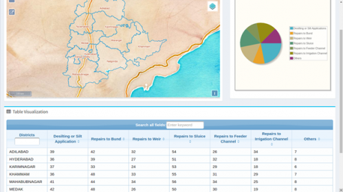
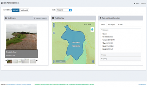
Mission Kakatiya is an initiative by Telangana State Government to restore minor irrigation sources of the region. Almost 85 percent of the cultivated area in Telangana being rain fed, minor irrigation sources such as lakes are very crucial for sustainable agriculture of the region. Government of Telangana is working on restoring all the lakes in the state for sustainable overall development of the state in a phase wise manner over a period of 5 years. To carry out this mission it is very important to create a comprehensive database of all the lakes and water bodies in the state, which number around 40,000 across the state with a total land area of 112,077 Sq kms. To develop such a baseline data required collating existing data sources, creating new data where-ever required by using state of art technology in Remote sensing and GIS and supplementing with field information to ensure that it is always supported by ground conditions. Remote sensing and GIS not only enable maintaining the lake information through mapping but also help planners and community by providing valuable information like the land use around it, temporal changes in the lake due to climatic and other anthropological reasons, and an assessment of the sustainability of these water bodies. A comprehensive information system called Lake Monitoring and Management System (LMMS) was developed and deployed with a key focus on Capacity building to support and supplement the activities of the stakeholders in the Irrigation and Command Area Development authority of the State Government. Some key components include lake geography, integration of hydrological structures and characteristics , domain based spatio-temporal analysis and a web based data visualization and dissemination framework that enhances decentralized planning and governance models across the multiple administrative levels including monitoring of various works taken up.